• Skip to main content
  • Skip to primary navigation
  • Departments
    • Bioengineering
    • Civil and Environmental Engineering
    • Electrical Engineering and Computer Sciences
    • Industrial Engineering and Operations Research
    • Materials Science and Engineering
    • Mechanical Engineering
    • Nuclear Engineering
    • Aerospace program
    • Engineering Science program
  • News
    • Berkeley Engineer magazine
    • Social media
    • News videos
    • News digest (email)
    • Press kit
  • Events
    • Events calendar
    • Commencement
    • Homecoming
    • Cal Day
    • Space reservations
    • View from the Top
    • Kuh Lecture Series
    • Minner Lecture
  • College directory
  • For staff & faculty
Berkeley Engineering

Educating leaders. Creating knowledge. Serving society.

  • About
    • Facts & figures
    • Rankings
    • Mission & values
    • Equity & inclusion
    • Voices of Berkeley Engineering
    • Leadership team
    • Milestones
    • Buildings & facilities
    • Maps
  • Admissions
    • Undergraduate admissions
    • Graduate admissions
    • New students
    • Visit
    • Maps
    • Admissions events
    • K-12 outreach
  • Academics
    • Undergraduate programs
    • Majors & minors
    • Undergraduate Guide
    • Graduate programs
    • Graduate Guide
    • Innovation & entrepreneurship
    • Kresge Engineering Library
    • International programs
    • Executive education
  • Students
    • New students
    • Advising & counseling
    • ESS programs
    • CAEE academic support
    • Student life
    • Wellness & inclusion
    • Undergraduate Guide
    • > Degree requirements
    • > Policies & procedures
    • Forms & petitions
    • Resources
  • Research & faculty
    • Centers & institutes
    • Undergrad research
    • Faculty
    • Sustainability and resiliency
  • Connect
    • Alumni
    • Industry
    • Give
    • Stay in touch
Home > News > Tracking smoke
Aerial photo of smoke from wildfires, with California county map superimposedPhoto illustration courtesy the researchers

Tracking smoke

Berkeley Engineer Spring 2022 cover
April 15, 2022
This article appeared in Berkeley Engineer magazine, Spring 2022
  • In this issue
    Colorful electron microscope image of pure titanium with a nanotwinned structure.

    A new time for titanium

    Old-style drawing of a cow

    The future of meat

    Artist

    On the horizon

    Dean's note: Public partners in innovation

    Upfront

    • Too good to be true
    • Tiny switches
    • Bakar BioEnginuity Hub opens
    • Seeing red
    • Making the cut
    • Tracking smoke
    • Q+A on wastewater testing

    New & noteworthy

    • The power of yes
    • Abbeel hosts AI robotics podcast
    • Farewell
    • With flexibility comes possibility
  • Past issues

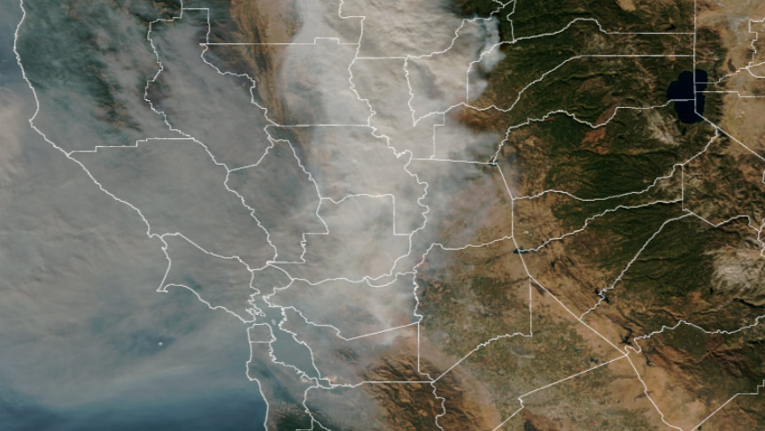
During the 2018 Camp Fire, Tina Katopodes Chow, professor of civil and environmental engineering, went looking for information on when the smoke might clear from the San Francisco Bay Area — more than 100 miles away from the wildfire raging in Butte County, California. What she found was a new experimental tool from the National Oceanic and Atmospheric Administration (NOAA) Global Systems Laboratory. Known as HRRR-Smoke, it is the only real-time 3D high-resolution U.S. weather forecasting model that predicts the movement and concentration of smoke. Using data collected by weather satellites, such as the radiative energy from a fire, the model estimates the amount of smoke emitted; it then computes wind speed and direction to predict the smoke plume’s trajectory, density and impact on weather and visibility.

After noticing some inaccuracies, Chow contacted the developers and offered to help test the model. Her team’s analysis found that HRRR-Smoke successfully forecast the general movement and concentration of the smoke plume, especially given the complex terrain and wind conditions. But it also identified aspects of the model that could be improved — such as how the arrival of smoke in the Bay Area as predicted by the model was delayed. Including high-frequency fire detections from geostationary satellites would help fires be detected more rapidly in the model, said Katelyn Yu, Ph.D. student and co-author of the study.

On some days, the model underpredicted the concentration of air pollution by 70%; the researchers believe that the smoke plume itself may be the cause of this error because the thick smoke blocked the satellites’ view of the fire. “To complement the satellite detections, we need to assimilate additional datasets into our smoke forecast models, for example the ground-based PM2.5 measurements,” said Chow, noting that NOAA researchers are continuing to improve the HRRR-Smoke model, which became operational in 2020.

Topics: Civil engineering, Sustainability & environment
  • Contact
  • Give
  • Privacy
  • UC Berkeley
  • Accessibility
  • Nondiscrimination
  • instagram
  • X logo
  • linkedin
  • facebook
  • youtube
  • bluesky
© 2025 UC Regents