Smart sensors in the woods

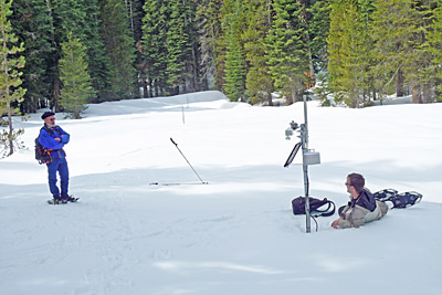
FIELD WORK: Steven Glaser (left), civil and environmental engineering professor, and his graduate student Branko Kerkez check a sensor node they’ve installed in the Sierra. Their wireless sensor network measures snowpack depth, soil moisture and other features critical to predicting spring and summer water availability. (Photo by The Researchers.)
About 60 percent of the water used in California comes from Sierra Nevada snowmelt. During the winter, intrepid snow surveyors ski and helicopter in to select mountain sites to measure the snowpack’s depth with steel tubes shoved into the snow. Those measurements, taken monthly, help water managers estimate the amount of water held in the snowpack and allow them to allocate the state’s most precious resource.
Now, the Sierra Nevada is going high tech. Wireless sensors developed by Steven Glaser, professor of civil and environmental engineering, are being tested in an ambitious pilot project directed by hydrologist Roger Bales at the UC Merced Sierra Nevada Research Institute.
The Berkeley-Merced collaboration uses a specially designed new generation of sensors that are the size of matchbooks and feature wireless, communicating microprocessors known as motes. These motes measure soil moisture, snow depth and other features critical to predicting spring and summer water availability. The system is designed to transmit the real-time measurements to researchers and water managers.
Glaser and Bales have established a 2.5-square-kilometer site in the Southern Sierra Critical Zone Observatory, or CZO, a National Science Foundation (NSF)-supported research site located in the mountains east of Fresno.
The project got a boost in October when the NSF awarded the researchers a $2 million grant to establish a much larger test plot. The four-year grant will allow the team to install more than 1,000 sensors throughout the 5,000-square-kilometer American River Basin north of the CZO site.
“Optimal usage of our scarce water supply requires that we know how much there is, where it is and where it is going,” says Glaser, who is faculty director of the Intelligent Water Infrastructure initiative at CITRIS. The Center for Information Technology Research in the Interest of Society (CITRIS) is a multi-disciplinary program that spans four UC campuses—Berkeley, Davis, Merced and Santa Cruz—and more than 60 industrial partners.

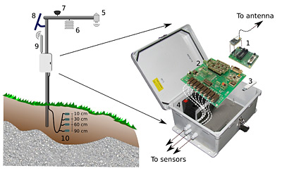
WIRELESS WONDER: Here’s a detail of a sensor node’s architecture: (1) mote (wireless component); (2) custom data-logger to interface the sensor array; (3) onsite storage; (4) 12-volt battery to power sensor array; (5) snow depth sensor; (6) humidity and temperature sensor; (7) solar radiation sensor; (8) 10-watt solar panel; (9) external eight isotropic decibel antenna; (10) 4 soil moisture, temperature and matric potential sensors at varying depths. Readings are taken at 15-minute intervals. (Photo by The Researchers.)
The researchers’ grid of independent but integrated sensors will not only improve estimates of water availability, but also help scientists understand large-scale processes that otherwise would be intractable. Incoming solar radiation, snow depth, soil temperature, atmospheric gases, plant respiration and moisture at different depths—the wireless grid can measure all these ecological features.
“We had this idea 10 years ago to create a network of sensors, which would communicate with each other, and together make a kind of giant array,” Glaser says. “At that time I was thinking about using it for earthquake monitoring. But Roger’s idea of using a sensor array to help predict water availability from an entire watershed seemed like an exciting opportunity.”
In place of the kind of yardstick approach traditionally used to measure snow depth, an acoustic sensor on a pole—mounted at a known distance above the rock—sends out an acoustic chirp that bounces off the rock surface and returns. This two-way travel time is measured. If winter brings, say, a two-foot snowpack, the surface is now that many feet closer to the sensor, so an acoustic signal will bounce off the snow and return more quickly. Since researchers know the speed of sound through air, they can estimate the distance between the sensor and the snow versus bare rock surfaces. Subtracting the first from the second gives the thickness of the snow.
“This is the same technology used by early auto-focusing cameras,” says Glaser. “You can actually hear the short little clicks of the acoustic signal.”
Branko Kerkez, a graduate student in Glaser’s lab, is the principal researcher on the ground trying to make sure the novel sensor network performs as intended. Raised in European and American cities, he was more familiar with the Berkeley coffeehouse environment than the great outdoors when he started the project.
“I thought I was going to grad school to do math, not hike in the snow,” he says. “At first, it was a clash of worlds. It’s a four- or five-hour drive, and then sometimes another hour of snowshoeing. But I’ve grown to like it. It’s very exciting to learn and then directly apply what you learn, and it’s aimed at such an important problem.”
Kerkez hopes to apply what he’s learned to improve large-scale water allocation and to mitigate flooding and produce hydropower.
The former coffeehouse habitué now says, “This is the ultimate project for me.”
Note: This article originally appeared on UC Research website, which is produced by the UC Office of the President.
